This overview of the science necessary to understand groundwater issues is taken from Chapter 2 of the Washington State, Department of Ecology, Ground Water Resource Protection Handbook, Published December 1986.
HYDROLOGIC CYCLE
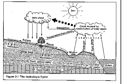
The hydrologic cycle is a constant movement of water above, on, and below the earth's surface. It is a cycle that replenishes ground water supplies. It begins as water vaporizes into the atmosphere from vegetation, soil, lakes, rivers, snowfields and oceans-a process called evapotranspiration.
As the water vapor rises it condenses to form clouds that return water to the land through precipitation: rain, snow, or hail. Precipitation falls on the earth and either percolates into the soil or flows across the ground. Usually it does both. When precipitation percolates into the soil it is called infiltration; when it flows across the ground it is called surface runoff. The amount of precipitation that infiltrates, versus the amount that flows across the surface, varies depending on factors such as the amount of water already in the soil, soil composition, vegetation cover and degree of slope.
Surface runoff eventually reaches a stream or other surface water body where it is again evaporated into the atmosphere. Infiltration, however, moves under the force of gravity through the soil. If soils are dry, water is absorbed by the soil until it is thoroughly wetted. Then excess infiltration begins to move slowly downward to the water table. Once it reaches the water table, it is called ground water. Ground water continues to move downward and laterally through the subsurface. Eventually it discharges through hillside springs or seeps into streams, lakes, and the ocean where it is again evaporated to perpetuate the cycle
GROUND WATER AND SUBSURFACE WATER
Most rock or soil near the earth's surface is composed of solids and voids. The voids are spaces between grains of sand, or cracks in dense rock. All water beneath the land surface occurs within such void spaces and is referred to as underground or subsurface water.
Subsurface water occurs in two different zones. One zone, located immediately beneath the land surface in most areas, contains both water and air in the voids. This zone is referred to as the unsaturated zone. Other names for the unsaturated zone are zone of aeration and vadose zone.
Figure 2.2
The unsaturated zone is almost always underlain by a second zone in which all voids are full of water. This zone is defined as the saturated zone. Water in the saturated zone is referred to as ground water and is the only subsurface water available to supply wells and springs.
Water table is often misused as a synonym for ground water. However, the water table is actually the boundary between the unsaturated and saturated zones. It represents the upper surface of the ground water. Technically speaking, it is the level at which the hydraulic pressure is equal to atmospheric pressure. The water level found in unused wells is often the same level as the water table, as shown in Figure 2.2.
AQUIFERS AND CONFINING BEDS
All geologic material beneath the earth's surface is either a potential aquifer or a confining bed. An aquifer is a saturated geologic formation that will yield a usable quantity of water to a well or spring. A confining bed is a geologic unit which is relatively impermeable and does not yield usable quantities of water. Confining beds, also referred to as aquitards, restrict the movement of ground water into and out of adjacent aquifers.
Ground water occurs in aquifers under two conditions: confined and unconfined. A confined aquifer is overlain by a confining bed, such as an impermeable layer of clay or rock. An unconfined aquifer has no confining bed above it and is usually open to infiltration from the surface.
Unconfined aquifers are often shallow and frequently overlie one or more confined aquifers. They are recharged through permeable soils and subsurface materials above the aquifer. Because they are usually the uppermost aquifer, unconfined aquifers are also called water table aquifers.
Confined aquifers usually occur at considerable depth and may overlie other confined aquifers. They are often recharged through cracks or openings in impermeable layers above or below them. Confined aquifers in complex geological formations may be exposed at the land surface and can be directly recharged from infiltrating precipitation. Confined aquifers can also receive recharge from an adjacent highland area such as a mountain range. Water infiltrating fractured rock in the mountains may flow downward and then move laterally into confined aquifers.
Windows are important for transmitting water between aquifers, particularly in glaciated areas such as the Puget Sound region. A window is an area where the confining bed is missing.
The water level in a confined aquifer does not rise and fall freely because it is bounded by the confining bed--like a lid. Being bounded causes the water to become pressurized. In some cases, the pressure in a confined aquifer is sufficient for a well to spout water several feet above the ground. Such wells are called flowing artesian wells. Confined aquifers are also sometimes called artesian aquifers.
When a well is drilled into an unconfined aquifer, its water level is generally at the same level as the upper surface of the aquifer. This is, in most cases, the water table. By contrast, when a well is drilled into a confined aquifer, its water level will be at some height above the top of the aquifer and perhaps above the surface of the land-depending on how much the water is pressurized. If a number of wells are drilled into a confined aquifer, the water level will rise in each well to a certain level. These well levels form an imaginary surface called the potentiometric surface. The potentiometric surface is to a confined aquifer what the water table is to an unconfined aquifer. It describes at what level the upper surface of a confined aquifer would occur if the confining bed were removed.
Figure 2.3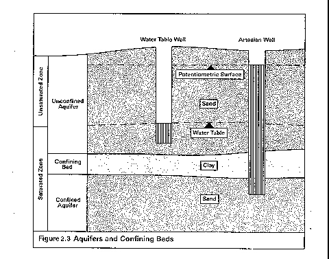
The most productive aquifers, whether confined or unconfined, are generally in sand and gravel deposits. These tend to have large void spaces for holding water. Rocks with large openings such as solution cavities or fractures can also be highly productive aquifers. Generally, the smaller the grain size or the less fracturing, the less water an aquifer will produce. This is because there are fewer void spaces for holding water.
GROUND WATER RECHARGE AND DISCHARGE
Recharge is the process by which ground water is replenished. A recharge area is where water from precipitation is transmitted downward to an aquifer.
Most areas, unless composed of solid rock or covered by development, allow a certain percentage of total precipitation to reach the water table. However, in some areas more precipitation will infiltrate than in others. Areas which transmit the most precipitation are often referred to as "high" or "critical" recharge areas.
As described earlier, how much water infiltrates depends on vegetation cover, slope, soil composition, depth to the water table, the presence or absence of confining beds and other factors. Recharge is promoted by natural vegetation cover, flat topography, permeable soils, a deep water table and the absence of confining beds.
Discharge areas are the opposite of recharge areas. They are the locations at which ground water leaves the aquifer and flows to the surface. Ground water discharge occurs where the water table or potentiometric surface intersects the land surface. Where this happens, springs or seeps are found. Springs and seeps may flow into fresh water bodies, such as lakes or streams, or they may flow into saltwater bodies.
Under the force of gravity, ground water generally flows from high areas to low areas. Consequently, high areas-such as hills or plateaus-are typically where aquifers are recharged and low areas-such as river valleys-are where they discharge. However, in many instances aquifers occur beneath river valleys, so river valleys can also be important recharge areas. Typical recharge and discharge areas are depicted in Figure 2.4.
Figure 2.4
GROUND WATER MOVEMENT
Gravity is the force that moves ground water which generally means it moves downward. However, ground water can also move upwards if the pressure in a deeper aquifer is higher than that of the aquifer above it. This often occurs where pressurized confined aquifers occur beneath unconfined aquifers.
A ground water divide, like a surface water divide, indicates distinct ground water flow regions within an aquifer. A divide is defined by a line on the either side of which ground water moves in opposite directions. Ground water divides often occur in highland areas, and in some geologic environments coincide with surface water divides. This is common where aquifers are shallow and strongly influenced by surface water flow. Where there are deep aquifers, surface and ground water flows may have little or no relationship.
As ground water flows downwards in an aquifer, its upper surface slopes in the direction of flow. This slope is known as the hydraulic gradient and is determined by measuring the water elevation in wells tapping the aquifer. For confined aquifers, the hydraulic gradient is the slope of the potentiometric surface. For unconfined aquifers, it is the slope of the water table.
The velocity at which ground water moves is a function of three main variables: hydraulic conductivity, (commonly called permeability) porosity, and the hydraulic gradient. The hydraulic conductivity is a measure of the water transmitting capability of an aquifer. High hydraulic conductivity values indicate an aquifer can readily transmit water; low values indicate poor transmitting ability. Because geologic materials vary in their ability to transmit water, hydraulic conductivity values range through 12 orders of magnitude. Some clays, for example, have hydraulic conductivities of .00000001 centimeters per second (cm/sec), whereas gravel hydraulic conductivities can range up to 10,000 cm/sec. Hydraulic conductivity values should not be confused with velocity even though they appear to have similar units. Cm/sec, for example, is not a velocity but is actually a contraction of cubic centimeters per square centimeter per second (cm3/cm2-sec).
In general, course-grained sands and gravels readily transmit water and have high hydraulic conductivities (in the range of 50-1000 m/day). Fine grained silts and clays transmit water poorly and have low hydraulic conductivities (in the range of .001-0.1 m/day).
The porosity of an aquifer also has a bearing on its ability to transmit water. Porosity is a measure of the amount of open space in an aquifer. Both clays and gravels typically have high porosities, while silts, sands, and mixtures of different grain sizes tend to have low porosities.
The velocity at which water travels through an aquifer is proportional to the hydraulic conductivity and hydraulic gradient, and inversely proportional to the porosity. Of these three factors, hydraulic conductivity generally has the most effect on velocity. Thus, aquifers with high hydraulic conductivities, such as sand and gravel deposits, will generally transmit water faster than aquifers with lower hydraulic conductivities, such as silt or clay beds.
Ground water velocities are typically very slow, ranging from around a centimeter per day to almost a meter per day. However, some very rapid flow can occur in rock with solution cavities or in fractured rock. Very high flow rates (more than 15 m/day) are associated, for example, with some parts of the Columbia River basalt in eastern Washington.
The volume of ground water flow is controlled by the hydraulic conductivity and gradient, and in addition is controlled by the volume of the aquifer. A large aquifer will have a greater volume of ground water flow than a smaller aquifer with similar hydraulic properties. But if the cross-sectional area-that is, the height and width-are the same for both aquifers, the aquifer with a greater hydraulic conductivity and hydraulic gradient will produce a greater volume of water.
How this relates to Leaking Sewers